|
|
Accessibility & Transport Innovation
Research Summary October 2003
The Case Study selected to trial my hypothesis is set in the context of a contemporary focus of urban planning in Sydney. The outer ring regions of Western Sydney have been observed as experiencing strong growth in a number of urban measures in the period from 1981 to 1996. Person kilometres of JTW travel increased dramatically in the 20 to 60 km band. The largest increases of the suburban workforce occurred in these areas, reflecting the largest land release areas. In addition the largest increase in regional jobs occurred with a change in proportion of total increased from 24% in 1981 to 35% in 1996 reflecting a move of business into these areas.
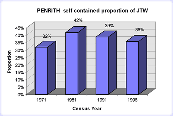
Two SLA�s within this band have been selected for detail application of the methodology and subsequent review. Campbelltown SLA is one of a few areas within the outer band region that has a depth of history to its urban story. In 1971 the Macarthur Development Corporation set in place one of the first intentional policies to develop both residential and employment areas together. The aim has been to provide opportunity for containment of jobs for local workers within the Campbelltown SLA. As a control, the Penrith SLA is included. It is an area similarly placed spatially from the CBD and Parramatta and connected with similar position to road and rail. It differs from Campbelltown in that it has not had a policy to encourage self containment, to the extent of Campbelltown SLA. Manning observes from the 1971 Census, that the expectation that balancing of jobs and resident workers would occur when jobs are located close to residences is patchy. Jobs close to home were often overlooked for better opportunities that were further away. Campbelltown take up rates were as low as 25% in 1971, while opportunities were available for 61%. Take up rates in Penrith were 32% in 1971, with opportunities for 95% to work locally. The context of the Case Study are the urban planning questions, does the intentional policy for self sufficiency in jobs, make any significant difference to response? And do residents still choose to bypass local jobs for other more distant jobs?
Comparison of the SLA level JTW data for each census between 1971 to 1996 was completed for Campbelltown and Penrith. The 1971 data was sourced from Manning�s 1976 publication. 1981, 1991 and 1996 data was sourced from census JTW tabulations provided by the NSW STSG . Both the 1991 and 1996 data is aggregated from travel zone level data.
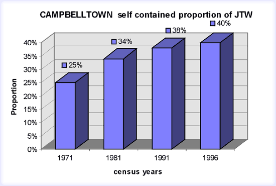
The data sets enabled each of the census years to be compared at the SLA level. Although there has been some changes to the SLA boundaries of 1991 and 1996 compared with the LGA boundaries of 1971 and 1981, these were not statistically significant for Campbelltown and Penrith at the aggregate level. Campbelltown SLA has exhibited an increasing proportion of JTW trips starting in Campbelltown being to destinations also within Campbelltown SLA. In the 10 years to 1981, a 9 % increase in the proportion took place. However, from 1981 to 1991 the increase was only 4%. This same rate of increase has continued to 1996.
Penrith SLA has shown a similar increase ( 10%) in the first 10 years to 1981, as Campbelltown SLA. However, since then it has exhibited an increasing decline in proportion of JTW trips starting in the Penrith SLA being to destinations within the same SLA. The decline was by 3% in the 10 years from 1981 to 1991 and by 3% in the following 5 years, from 1991 to 1996.
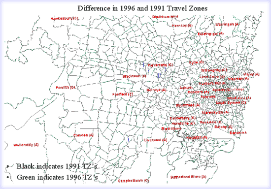
The 1991 and 1996 data sets included travel zone level JTW data. This has enabled a look into this disparity between the two SLA�s. Figures below are overlays of 1991 and 1996 data sets.
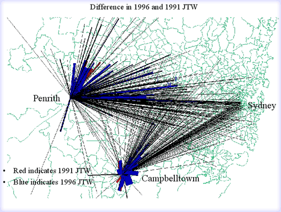
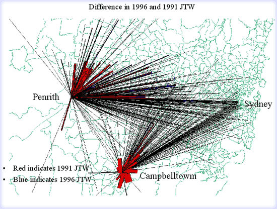
Penrith has a greater number of trips to more distant destinations appearing on the figures. Campbelltown on the other hand shows a greater increase in the JTW trips to closer destinations. The period from 1981 to 1996 has been observed by Kamari 2 to have shown a 46% increase in regional jobs in the middle/outer ring areas of Sydney. Campbelltown�s industrial lands at Minto and Ingleburn contribute significantly to this trend. Penrith trends have been influenced by the growth in trips to destinations in the areas at Wetherill Park and the Huntingwood areas, where growth in industrial job availability has increased. The access, provided to these areas by the M4 motorway appears to be significant. It should be noted that growth in local trips has not been stagnant in Penrith SLA. The reduction in proportion appears to be a combination of lower growth in local jobs than in Campbelltown SLA and the pull of an accessible pool of jobs in the adjacent SLA�s of Blacktown and Fairfield. Still to be considered is the question of job take up compared with jobs available.
Within this context , this Case Study is continuing its focus on the twin SLA�s of Penrith and Campbelltown, to explore both the methodology of this thesis and to attempt to provide explanations for these urban context questions.
In my previous review I outlined the methodology to be followed in this Case Study. The base year of the model testing is 1991. The census JTW data has as explained, been assembled for both 1991 and 1996 at the travel zone level.
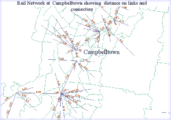
The modelling platform is Transcad version 3. The focus of the modelling in stage1 is to calibrate a traditional transport planning model to the JTW data sets of 1991 and to then further validate this by using the model to predict the 1996 dataset. The origin zones have been restricted to those in the twin SLA�s of Penrith and Campbelltown.
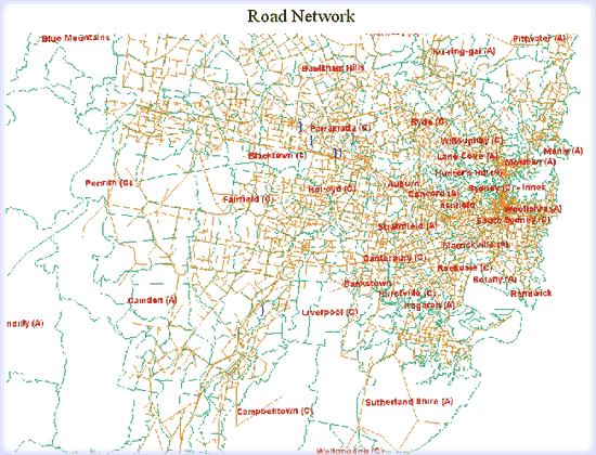
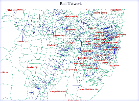
A challenge has been in the assembly of base zonal and network data. Data has been acquired with the assistance of the Built Environment Faculty. However a major difficulty has been the fitting together of this data on a common coordinate system. Further difficulty was experienced in assembling road and public transport networks, together with their attributes from incompatible model formats. The networks developed and the zonal systems used are shown in the attached figures.
A conscious decision has been to limit the Case Study to focus on trip distribution modelling and not trip generation. This is because the available data is the JTW, is able to provide total origin and destination trip totals, or in effect the trips generated. The modelling can be restricted to predicting a distribution that can be compared with JTW origin/ destination actuals, thereby keeping the complexity of the modelling under control. A distribution and mode split model may be necessary, however for keeping the analysis manageable, data on JTW between travel zones by mode would enable this to be avoided.
- Black,J., and Suthanaya,P.(2002) Statistical and spatial modelling of vehicle kilometres of travel by car for the journeys to work in Sydney, 1981 to 1996 : implications for sustainable transport targets. Papers 25th Australasian Transport Research Forum, Canberra, ACT, October 2002
- Kamari S., (2002) Changes in Accessibility to Employment in Metropolitan Sydney, 1991 to 1996
- Manning I., (1978) The Journey to Work; Urban Research Unit , Australian National University
- NSW State Transport Study Group
|

|
|